A brief history of Red Cliffs
Red Cliffs, Victoria 3496
Location
Red Cliffs is the southern gateway to Sunraysia on the Calder Highway. Known as Big Lizzie Town, it is 16 kms from Mildura and 544 kms north west of Melbourne. A thriving community, with a population of 4625 (2011), it borders the Murray River to the east and the vast Murray Sunset National Park to the west.
Settlement
We take our name from the magnificent cliffs towering over the Murray River to the east of the settlement. Middens along the base of these cliffs are evidence that this stretch of river was heavily populated before it was named Red Cliffs.
This land was part of the giant Yerre Yerre, later Mildura, Pastoral lease. The Karadoc Woolshed was located here atop the cliffs.
The area was part of the Chaffey Indenture of 1887. A site below the cliffs was considered as the location for the pumps for the Mildura Irrigation Colony. This did not eventuate as the cliffs proved too high for the engineering of the time to raise the water.
Following World War 1 there was a need for the Government to repatriate over 300,000 Diggers back into civilian life. The Red Cliffs bushland was put forward as a possibility for irrigated settlement blocks. On April 25th 1919, negotiations commenced with the liquidators of the Chaffey Bros. Ltd and by December that year a total area of 33,000 acres was purchased by the Government, of which half was to be for irrigation – consequently Red Cliffs became the largest Soldier Settlement in Australia.
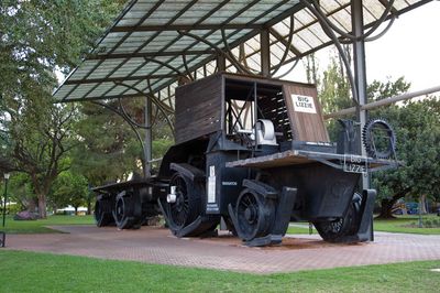
The area was surveyed into blocks averaging 16 acres. By mid-1920 workers were arriving at the rate of about fifty a day. They were divided into 30 work gangs with the back-breaking task of clearing the land. The arrival of ‘Big Lizzie’ greatly assisted the work as she could pull up to eight Mallee stumps at a time. The State Rivers & Water Supply Commission under the direction of A.S. Kenyon were responsible for surveying and all construction works, including over 120 miles of concrete-lined channels. The first allocation of blocks was announced in December 1920. A further four allocations were made, making over 700 blocks in total. Three million vine cuttings were established in the nursery on the ridge. Water first pumped into the channel and onto the blocks in October 1921.
The Karadoc Woolshed was re-located west of the railway to accommodate the workers, and served a variety of purposes including social centre, church and the first temporary school. A tent town grew beside it with accommodation for families and commercial businesses to service the community. The shared past experience forged in battle and the Digger camaraderie and industry in establishing their settlement created a unique spirit of mateship, unity and purpose.
Once clearing was completed the settlers moved onto their own blocks and a more permanent township was built on the eastern side of the railway. The roads were named in alphabetical order, the streets running north/south after trees and the avenues running east/west after rivers. A central square was laid out for public use. Red Cliffs quickly developed. By 1924 the blockies cheered as the first shipment of their dried fruit left by train from their Co-operative Packing shed.
The RSL became a strong support for this unique settlement of ex-Diggers. Red Cliffs was not unnoticed. In 1954 Red Cliffs RSL was asked to host part of the Australian Royal Tour. Over 30,000 people filled Quandong Park to see the Queen and Duke. The Diggers marched proudly making it the biggest event ever for Red Cliffs. The Diggers’ spirit was again demonstrated in 1956 when all rallied day and night to defend the pumping and power stations from the devastating floodwaters.

Red Cliffs & District Historical Society

The Red Cliffs and District Historical Society was established in 1984 to fulfil the important role of preserving and recording the history of Red Cliffs & district. In 1994 the Society was granted permission to use the Court House as a permanent base and this now provides a home for a collection of historical items, photographs, newspaper articles, books, maps and memorabilia.
Open Days are conducted on the first Sunday of each month between 10am – 12 noon. Admission is $2 for Adults – Children accompanied by an adult are free.
Other times: Private viewings at other times by prior arrangement only. Special arrangements will be made for schools and group visits.
Please contact us to make arrangements or to request more information.
The Red Cliffs & District Historical Society is a repository for the history of the following areas:
Red Cliffs Irrigation Settlement (This includes Red Cliffs East, Nursery Ridge, Cliffside, Sunnycliffs, Stewart and Cardross.)
Karadoc, Iraak, Nangiloc, Colignan, Thurla, Yatpool, Carwarp, Nowingi, Hattah.
Red Cliffs, Victoria 3496
Red Cliffs Today
The early settlers’ hope for a prosperous, safe and vibrant community has carried through the years and is still evident in the culture and daily life of Red Cliffs. Today some of our original blocks are still in production but industry has diversified. Our community supports sporting, service, artistic, cultural and interest clubs. We value our kindergarten, schools, churches and Jacaranda Aged Care. The settlement provides a range of businesses, a Community Club, swimming pool, parks and playing fields. We take pleasure in our surrounding bush and river environment.
‘Big Lizzie’ stands in our square reminding us of the effort of our pioneers in the beginning years. We are approaching 100 years since that soldier settlement began. Together we developed this Community Plan to celebrate our centenary and ensure tomorrow’s Red Cliffs remains a great place to visit, work and live.
Acknowledgement of Country
We acknowledge the traditional custodians of the country on which Red Cliffs now stands, the Latje Latje people and their neighbours the Barkindji, and pay our respect to their elders past and present.